Your Cart is Empty

Trip Report: Spring In Pine Creek Pennsylvania
View From Turkey Path Trail looking towards Pine Creek Rail Trail mile 12.5
Make the Most Out of Your Adventures With Purple Lizard Maps
by Lizard Seeker Emily Newman
This wasn’t my first time in Pine Creek. My first time was years ago with a college friend who was supposedly familiar with the area. We drove along Route 44 for miles looking for Hoffman Campground before I stopped him and said, “Hey, do you know where we are going?” followed by “Do you have a map that we can look at?”
Back then, we did not have a map, or cell service, to obtain any information about Hoffman Campground. We stopped in Blackwell to ask a local for more information about Hoffman Campground:
“Oh yeah,” the local said, “Park at Rattlesnake Rock and walk North on the rail trail about a mile and you’ll see it on your right hand side, just by the water.”
We looked at each other with exactly the same thought in our heads — we had made reservations for a campground that is not accessible by car and we had no idea.
So we were off to Plan B — we decided to drive down South on the road a bit. “I think I remember a Campground near Slate Run,” my friend said. Sure enough, there was, but again we were caught unprepared, we didn’t know that the campground was permit camping only and we didn’t have one. It was getting late, so being adventurous, we decided to “just wing it” (I figured I could try to sweet talk to the park ranger, if necessary).
That experience added a lot of anxiety to what was supposed to be a fun and relaxing bike trip adventure. Several times throughout the trip, I thought, “A detailed map would have really solved all of our problems!”

Cue the Pine Creek Lizard Map
Earlier this month, years after my first bewildering Pine Creek experience, I had the opportunity to explore Pine Creek with the Purple Lizard Trail Guru. We had three full days of vacation and we were planning to make the most of it. So we wouldn’t waste any time, we started by pulling out our recently released Pine Creek Purple Lizard Map and created our own adventure!

Day 1: Biking the Pine Creek Rail Trail
The Pine Creek Rail Trail is one of the area’s most well known outdoor recreation resources in the area, so we started there. Since we were staying near Waterville, we quickly identified the nearest parking area, Waterville Parking Area, biked 11 miles north on the gravel rail trail to Ross Run and 11 miles back. It was a beautiful Friday and we saw more turtles than people along the rail trail. The water was flowing quickly that day, and it was gorgeous.

Gantz and I agreed that this trip was not only about the miles we could accumulate on feet and wheels — we also wanted to see what local libations we could enjoy. On our way back from the rail trail, we stopped at Happy Acres Resort to refuel on fresh cut french fries and a beer.Happy Acres Resortis an awesome place to stop while in Pine Creek! They have a camp store, gift shop, restaurant and bar, as well as overnight accommodations of all kinds. We met several Pine Creek locals, and learned about some upcoming races that were going to be happening this Spring and Summer. There is even Wifi available at Happy Acres, if you are not lucky enough to be able to disconnect for a few days.

Early Spring Along the Pine Creek Rail Trail
Day 2: Wellsboro and the Grand Canyon of Pennsylvania
We kicked off our second day early and stopped in Wellsboro to grab a latte to go. We continued west from there, as I was eager to check out the local guiding and shuttle service and outdoor equipment rental shop,Pine Creek Outfitters in Ansonia, which was loaded with folks preparing to head out on the water for the weekend. We also wanted to see the Northern Terminus of the West Rim Trail, so we followed the map, took Colton Road south, and parked at the second parking area, approximately 4 miles back on the right hand side. Gantz wanted to show me an awesome vista and Barbour Rock. I spotted the tiny Purple Lizard on the map and knew before we even arrived it was going to be a great view!
I was not disappointed. The vista right along the West Rim Trail shows a breathtaking view of Pine Creek, the rail trail, and we were able to visually follow the West Rim Trail on the ridge south of us. We even saw a kayaker flip their boat in the rapids below, and were reminded that Pine Creek boating can be serious business.

Pine Creek View in Early Spring
Freshly caffeinated and invigorated, we hopped back into the car and headed to the Darling Run Parking Area where we biked south on the rail trail to the Tiadaghton Access Area. Gantz made a special effort to check out the “primitive camping along Pine Creek” noted on the map with an eye for planning future adventures. The campsites there were spectacular. Located directly at water’s edge, there were several fire rings, rest rooms and picnic tables. We stopped around lunch time; several boaters had also stopped for lunch. Fires were warming the boaters as they cooked a delicious smelling meal. It seemed as though we were crashing a party, but folks were very friendly!

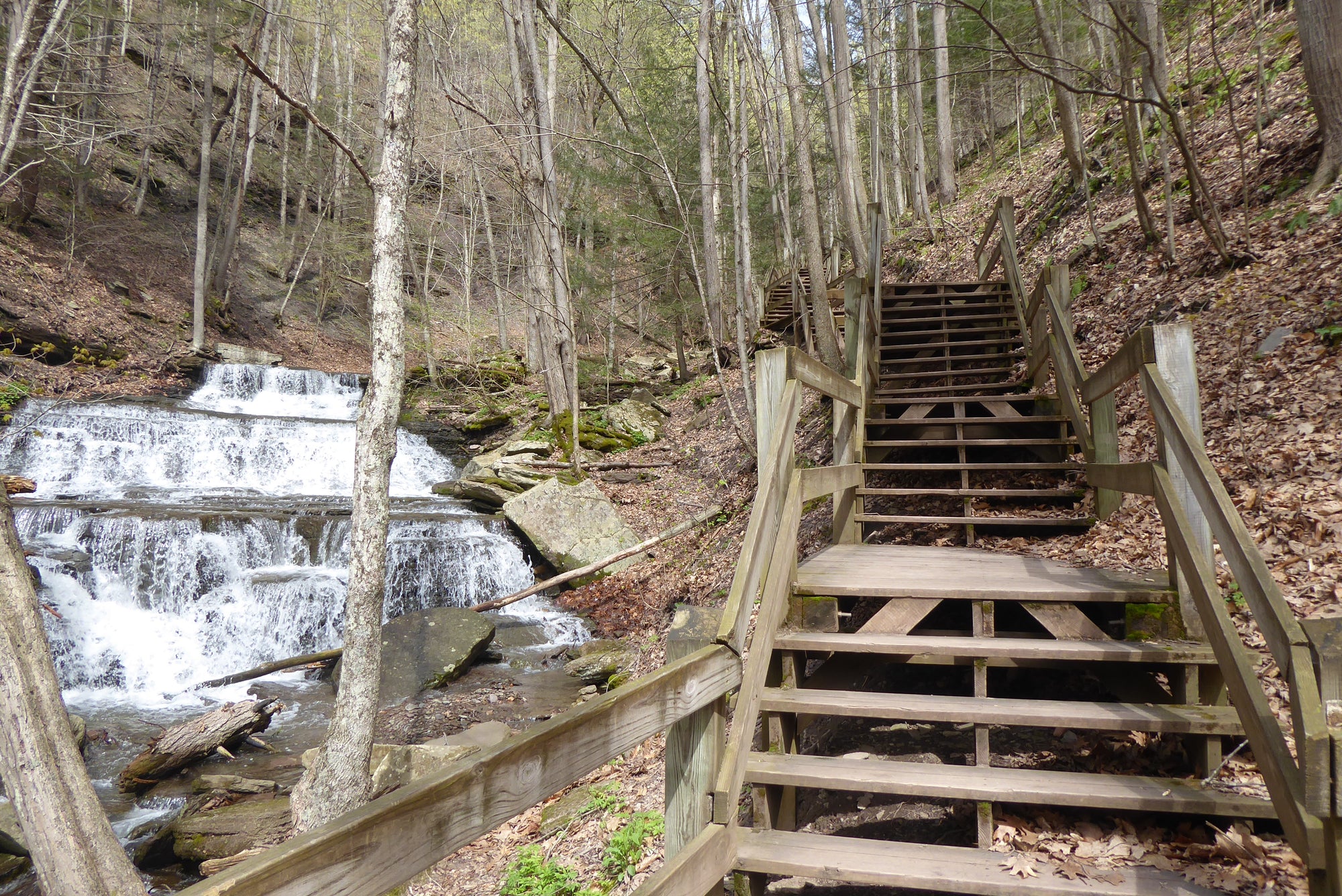
We biked back north but made a pit stop at the Purple Lizard spot near mile 12.5 of the rail trail. We really did not know what to expect, but what we saw was easily my favorite part of the whole weekend.

Waterfalls of Little Four Mile Run along Turkey Path Trail
And not only were there spectacular waterfalls, but there was also an awesome hiking trail, Turkey Path Trail, that led to the top of Leonard Harrison State Park — the pinnacle of the Grand Canyon of Pennsylvania. We explored all aspects of this area, even climbing out to Otter View—each special little Lizard spot was more beautiful than the next!

We climbed back down Turkey Trail and road our bikes back to Darling Run. We finished our evening by chowing down at Waterville Tavern in Waterville.
Day 3: Bob Webber Trail
On the last day of our Pine Creek adventure, Gantz gave me the reins and said that we could hike wherever I chose. I was interested in finding a short hike, hard climb and a great view. We checked out the map and found several options as this area is filled with steep climbs, but I ultimately landed on the Bob Webber Trail (mainly due to its to its proximity toWolfe’s General Store & Slate Run Tackle Shop, which meant post hike ice cream! I had never been on the Bob Webber Trail and Gantz had hiked it once, but he kept the secret of the stunning vista that would be waiting for us at the top, so it was a fantastic surprise.

Wolf Run Bald Vista Looking at Ravens Hern on Golden Eagle Trail
This hike is not for the faint of heart. Switchbacks climb what seems like straight up the mountain. Eventually we reached a trail register and of course that breath-taking vista. This out and back is short, about 3.5 miles round trip, and a bit of a challenge, but in my book it is a must-do for those interested in hiking Pine Creek.
After we finished, we shared an ice cream cone and recapped what a great weekend it had been!
Having the Purple Lizard Map of Pine Creek really did allow us to plan and make our own adventure in Pine Creek. Even though we only had three days, we were able to explore a small portion of what Pine Creek has to offer. We are already planning our next trip and will definitely hit some more special little Purple Lizards next time!
Want to plan your own Pine Creek Adventure? Check out the Purple Lizard Pine Creek Map.

Make Your Own Adventure With Purple Lizard Maps!
Copyright Purple Lizard Maps. All Rights Reserved.